
We brought the little suitcase of Google Nexus Devices to the Christa McAuliffe Technology Conference, held in Manchester on December 3, 2014. Ina Ahern and I were presenting a morning workshop titled Smart Maps Get Even Smarter! that made use of previously created, borrowable Editable Feature Services, and their use on hand-held devices (also borrowable), and we had planned/hoped for an opportunity to “go outside and collect data”.
We planned to gather data points and information about the parking behavior of conference attendees, and of other hotel guests, similar to the workshop that we did at the NEARC conference in Connecticut, the previous month. However… when we considered our circumstances at the Radisson Hotel/Center of NH Expo Center, we realized that the nearby parking was in a multi-level parking garage. We did not know if the Google Nexus devices would get satellite signals necessary for GPS location on the lower levels… and we knew that it would be impossible to manually map the inputs, as no image of the lower levels of the garage was geo-referenced. After some thought… we decided to concentrate on the roof-top parking level. Most problems would be sidestepped.
(Aside: in retrospect… I wonder, if we had been able to geo-reference a sketch/layout of the lower level parking… perhaps as separate maps? would that solve the problem? Even without the GPS capability, the power of mapping manually would still be available… I think. But what about the multi-level nature of the garage? Would we need another “field” named “Level”? Or “elevation”? Is there another way to account for data points that share latitude and longitude coordinates, but have different elevations? Perhaps something to think about… and experiment with.)
As mentioned ,we had planned to walk out onto the parking garage roof to gather data points and information Unfortunately… it snowed/sleeted/freezing-rained during the night before and during that early morning drive, and so our planned field trip was put in some jeopardy. When it became time to take the session participants outside, we walked down the stairs from the mezzanine level, out to the garage, up the elevator, and out onto the garage rooftop, crossing our fingers that icy conditions had moderated. Luckily… they had. We split up into 4 groups, and within 10 minutes, had gathered data points of the entire rooftop.
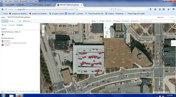
Back in the session meeting room, we demonstrated synchronizing the singular devices, combining all collected data points, and… displayed our group results. Teachers were interested in doing similar classroom projects, and were very interested in the fact that these Google Nexus devices would be borrowable. We think we made some friends!

 RSS Feed