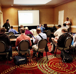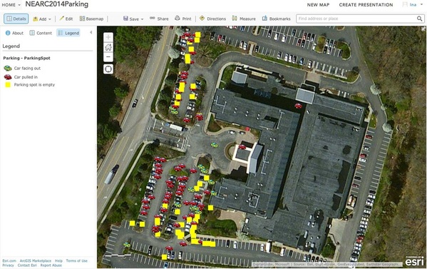
GIS Educators Day is a pre-conference held each year the Sunday before the Northeast Arc Users (NEARC) Fall Conference. This year the conference was held in Mystic, CT; and NHEdGIS team members presented and co-presented many of the sessions. One of the final hands-on sessions of the day, and also one of the best attended was “Using Esri’s Collector App for Field Data Collection with Your Students.” This session focused on using mobile devices (the Nelson Grant Nexus devices and UNHCE iPads) to collect data on parking practices and answer questions raised by the article http://www.npr.org/2014/08/27/343623220/parking-behavior-may-reflect-economic-drive
As the workshop was only an hour in length, it was critical that the mobile devices be prepared ahead of time. This presented our first challenge. Judy Tumosa (NH Fish and Game) and I arrived at the Mystic Marriott, had a quick dinner, and then began individually preparing each device. First Challenge: Although in-room Internet access was free, you are only allowed to connect 3 devices per room. A problem when in addition to your laptops you have 15 iPads and 12 Nexus Devices all of which need to be prepped for the workshop. Solution: The hotel lobby has free wireless available. Grab the suitcase of Nexus Devices (Nexi?) and the suitcase and bag of iPads and take the elevator down to the lobby. Fortunately, this hotel lobby had a wonderful long table with desk chairs set up that was just perfect for the task at hand. In addition each leg of the table had two electric outlets, which in combination with the power strips we brought let us work on charging the devices at the same time. Now to load the devices. Judy and I set up next to each other and began….enter the passcode for the device. Connect to the wireless. Launch a browser and agree to the terms. Launch the Collector app. Sign in to the NHEdGIS ArcGIS Online organizational accounts with one of the generic Publisher accounts. Find the NEARC Parking Map. Zoom in to the Mystic Marriott Parking Lot. Set work area. Zoom in as far as the map will allow. Set map detail. Download map. Select the option to download new basemap….select aerial imagery. Leave that device downloading and move onto the next. When the map is downloaded, return to the first device and open the map. Make sure everything is working and then let the device go to sleep. About this time Margaret Chernosky, a fellow T3Ger and good friend from ME arrived and volunteered to help. With three of us working, we were able to get all the devices prepped in short order. We did learn a few things:
1. Zooming in to your own school is easy….you know what it looks like from the air. Zooming in to a hotel in different state is a bit more challenging. Within the download area of the Collector app there’s no search option. Initially, we brought the area up in a web browser on the laptop, and then used that to help us locate the right area. Finally we figured out that if we entered one data point on the map at the hotel location, we could easily see that when we went to download…..so much easier and faster!
2. If you don’t get the download right the first time, it’s a problem to try again. For example, if you select too small a work area or forget to download the new aerial imagery for that area there’s no “Try Again” option. That night, we couldn’t figure out how to get rid of the map at all, so what we ended up doing was signing out of ArcGIS Online with that particular Publisher account, and then logging back in as someone different. Since then I’ve been told it is possible to delete the map off the device, but have yet to play with that.
Thanks to Margaret’s and Judy’s help, we finally had all the devices ready to go and were able to carry them back up to the room. By unplugging practically every other device in the hotel room, we were able to get all the ones that were not fully charged plugged in so they would be ready for the morning. I have to admit, it sure was a lot easier dealing with the 27 mobile devices in three small “suitcases” then it would have been with a similar number of laptops. I think the largest mobile laptop lab I ever set up was 18, and I barely managed to get them all in my car without any passengers!
Our workshop began with an introduction by Bob Woolner (Hopkinton Middle High School) and then some sample data and maps collected and prepared by Scott Semmens (Hopkinton Middle High School) from his Africa trip. In addition to his cool images of tracks, he was able to emphasize the real advantage of collector….being able to collect data while disconnected and then syncing to the map when Internet access is available again. Bob then introduced today’s data collection project and I demonstrated how to collect a data point using the Collector app on an iPad. It was at this point that it occurred to me we really needed to have the ability to project the Nexus device as well. Although the process is the same, the tools, menus, and placement of items is a little different on Android OS and in the future it would be great to be able to project both screens side by side so each participant will be able to see exactly what they need to do. In this case, when we first went out, we just made sure that all those using the Nexus Devices had one of our trusty co-presenters along with them while they collected the first few points. (In addition to those mentioned above, special thanks to Shane Bradt of UNH Cooperative Extension and Marcel Duhaime of Bow High School for providing this support.)
Given the short length of the workshop, participants only had about 15 minutes to collect data. Upon return to the meeting room, data was synced and participants and facilitators alike were amazed at the quantity of data that was collected in such a short time. Although we didn’t have time for analysis, options were discussed, and will be explored at our next Cloud Connected Mapping workshop taking place at the New Hampshire Science Teachers Association fall conference on November 2nd. As a four-hour field trip, this workshop will allow participants to not only collect data, but also to go through the process of setting up the mobile device for data collection. Also coming up on November 8th is our Editable Feature Service workshop with Kathryn Keranen. For more information on either of these, check out the postings to the NHEdGIS Collaborative Ring at http://www.nhedgis.org/collaborative-ring.html


 RSS Feed
